Pyrenees, July 2004

Le Mourguillou hut
I left Brussels early Saturday morning. 13 hours later, I stepped out of the train at Mérens-les-Vals, and soon on to the trail. As it was already evening, I was fortunate not to have more than a couple of hours to walk before reaching the small Le Mourguillou hut, where I slept the first night.
As a side note of interest, the Tour de France had actually finished that day's stage just 5 miles away (in a straight line - which isn't remotely possible by foot or bike) at the Plateau de Beille.

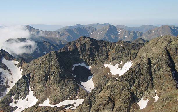
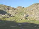
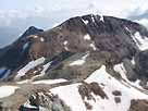
My ascent route up Pic
de Rulhe
I had a good half-day's walk ahead of me before reaching the base of my target peak for the day, Pic de Rulhe, and I was lucky the weather stayed reasonable, if not sunny.
My descent route down
Pic de Rulhe
I dithered over whether to go the way shown on the photo, or to do the shorter but steeper scramble up to the opposite ridge (to the right in the photo), and then face a harder ridge to the top.
As it happens, my route itself turned out to be quite a steep pull up a part rocky, mostly grassy slope. The ridge, however, was easy. The summit, at 2783m, was a good way to start.
The late afternoon mist moved in from the north after I had got down from the Pic, and the Refuge de Rulhe was immersed in the fog as I passed. I set up camp down the valley by the lake of l'Estagnol.

First campsite
After an unusually restless (and occasionally scary :-o ) night, morning brought great weather - you can tell the mist didn't prevent me from finding a marvellous spot.
I spent the rest of a warm day travelling west, including contouring around the magnificent steep-sided bowl at the head of the Coume d'Or. On several occasions the path took me to within a kilometre of Andorra, but always with a climb up on to a high ridge to my left separating me from the border. I camped within striking distance of the Pic de Serrera, at around probably 2200m.

Plotting a route up Pic de Serrera from the French side, the summit out-of-shot to the left
A little far-off lightning in the night didn't affect the weather the next day, which was again perfect.

On top of Pic de Serrera,
at a height of 2912m. The
border crosses the summit.
A short hike up the higher reaches of the valley took me to a point where I could plot a route up Pic de Serrera.
In the absence of any real path, I picked what seemed the most straight-forward route, first aiming up the scree to the right of the lowest col, and then cutting across left below the crags to avoid the snow. It wasn't so easy, but once I had reached the col and caught my breath, the ridge was no problem.

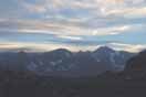
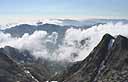
Andorran panorama
Having made the top in good time, I headed down into Andorra, where I temporarily joined the HRP as it crossed the Collada dels Meners col.
I headed east to meet the Ransol valley, and looked at this view as I ate lunch.
As it turned out, the hardest part of the day was yet to come, as I proceeded down the valley in the sweltering heat to reach the small town of Canillo (down to a height of just 1519m!). After stocking up on food and having an early evening meal at a crêperie, I commenced my journey back up again...

At sunset
The sun setting
The intermittent Andorran sign-posting didn't make things easy, and nor did the flies down in the woods. I made it to the Vall del Riu cabin at about 2100m, just above the tree-line, as the light was already starting to fade. Fortunately I was in time to catch the sunset. I stayed the night in the cabin.

Cabana de la Vall del Riu in
the morning. (The left room is the
dining room / common room and
the right room is the bedroom.)
Having completed the huge journey of the day before, I was at least in the right location for my next summit.
Having gone back almost to the location of the Pic de Serrera, but on the other side of the valley,
Pic de Serrera from
Pic de l'Estanyo
my route up Pic de l'Estanyo gave me good views over to the previous day's peak.

Pic de l'Estanyo Summit
The Pic de l'Estanyo proved an easier climb, although it took me (just) higher than the day before, to 2915m.
I was well off the ridge by the time a short thunder-storm broke in the mid-afternoon. I was surprised by its lack of substance, and it was soon replaced with sunshine again. The effort of the past few days hit me slightly and I went slower than I expected. By the time I reached the cabin at Rialb I couldn't travel any further.
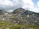
The next day I tried for another 2900+m peak, the Pic du Port. OK, so it didn't actually have a path marked up it on the map, but the ridge didn't look too difficult. And I did even see a sign-post to it.
After getting up to the col to its south, the Portella de Rialb, I dumped my rucksack and made it half-way up the rocky ridge. Nerves got the better of me, and I turned back before reaching what looked like a particularly tricky bit. I'm sure I could have done it, but on my own, I didn't fancy the risk it brought.
Somewhat irked, though not regretful (I'm still certain turning back was the right decision) I headed down to the ski resort of Arcalis.
It was a pity, really, that they hadn't seen fit to update the maps since 1987 (such is the way with the Andorran content on a French IGN map),

From the summit of
Pic de Cabayrou
as the expanded ski complex had apparently reshaped the mountain - or at least the paths on it.
This afternoon was one of the hottest of my trip, and with the help of a few lucky navigational guesses as to where they might put this chair-lift I saw, I finally got to the top of the ridge - and the border.
I made up for my earlier failure with a small ascent up the Pic de Caraussans and the Pic de Cabayrou (2733m) - easy when you're already on the ridge.
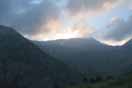
Mountain-side idyll
Dusk
Back on the French side, I found the perfect place to camp; a high meadow on the western slope, with gentle trickling streams weaving between the hillocks, and plenty of grassy expanses suitable for pitching a tent. A flock of sheep grazed quietly there, beneath the rocky outcrops of the slopes above.
and I watched the sun set over the mountains on the opposite side of the valley.
Summit of
Pic de la Rouge
My next day was a relatively relaxed one. It took me right down to 1800m at the bottom of the Soulcem valley, and then back up the other side. By early afternoon I had reached my intended campsite, by the Étang de Roumazet. (Having chosen it based solely on the map, I was glad it did indeed turn out to be suitable.)
Having pitched my tent and dumped most of my gear, the hike up the Pic de la Rouge (Pic de la Soucarrane) was at least a bit easier than normal - though it still took a bit of effort to get up to the summit at 2902m.
It was just one of these times when the mist, such as it was, surrounds everything but envelopes nothing...
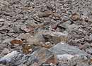
Rock field
Indicated with yellow paint markings, the path took me down over a rock field.
Just as I was taking this photo, on the descent from Pic de la Rouge, I heard a sharp crack somewhere above and behind me... then another crash... and another one, stone on stone... and then the broken rock bounced past 10 metres to my right and came to rest somewhere below me... I didn't stay too long after that!
The next day I had a long distance to travel - I was absolutely the wrong side of the Montcalm massif, and in the absence of a decent map of the Spanish territory (which
might have made things easier), the options were limited.

Mist over the Étang
de Soulcem Reservoir
The only realistic way was to descend, descend, descend, trek along the roads for quite some time and then regain all my height, and some more...
My first step was to head back on down to the Soulcem valley, and follow the road down to the Étang de Soulcem Reservoir. I found it capped with its very own portion of mist.
After a couple of flat kilometres along the eastern edge of the reservoir, and a steep descent by the dam, I followed the road down and down, eventually to a low-point of 1043m at the village of Marc, 1100m below where I started the day.
Having done that, I started on the up!
I wanted to get a good start the next morning, so my aim was to camp higher than the refuge at l'Étang du Pinet, 2224m.

The Étang du
Montcalm
I already guessed that the suitable tent-pitching spots would be limited in the rocky surroundings indicated on the map. But my guidebook indicated a great place to camp at the western end of the Étang du Montcalm.

Sunset at 2560m
And that's exactly where I did camp, in a sandy spot especially cleared of stones and protected from the wind by rock walls - and this is the view of the lake from there.
2560m was cold - in fact I had already passed a bit of a glacier in the valley some way below me earlier in the day. I quickly went to bed after the sun set behind the hills.

Ice floating in the lake
When I awoke at 7 the next morning, I found lumps of ice floating in the lake - they had broken off some of the remaining snow patches which trailed the edges of the water - but it was certainly cold enough not to melt them quickly.
At this height, it was really cold in the morning before the sun rose above the surrounding mountains, even if my campsite was well sheltered from any wind.
I left by 8 (although a few people who must've got up
very early had already passed my tent before I started off). Fortunately I didn't have so much height to attain, and once more I left most of my stuff in my tent.
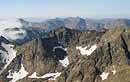
Summit of Pic du Montcalm, with Pica d'Estats behind
I got up on to the summit of my first peak of the day, the Pic du Montcalm, 3077m, at 9:20.

View from Pic du Montcalm
View from Pic du Montcalm
Although slightly lower than the Pica d'Estats, geography gives Montcalm some claim to domination of the group, and as much prominence as Estats, especially from the French side.
The views were breathtaking.

Ridge-top snowman in
front of Pica d'Estats and
the Pic de Verdaguer
The ridge route between Pic du Montcalm and the Pica d'Estats was relatively straight-forward, with a well-trodden path and only some gentle patches of snow.
Someone had recently been busy making a snowman on the top of the ridge between the two peaks.

The summit of
Pica d'Estats
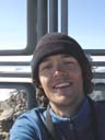
Me at the summit
of Pica d'Estats
Pica d'Estats, at 3143m, was my ultimate target and the highest summit of my trip. It's yet another high mountain whose summit lies on an international border.
The summit was very popular - by the time I arrived, many hikers from both the French and Spanish sides were also reaching the top.

Looking down from
Pica d'Estats
Pic du Montcalm from
Pica d'Estats
View South-East into
Spain from Pica d'Estats

The summit of
Pic de Verdaguer
The Pic de Verdaguer, in reality just a subsidiary top of Pica d'Estats, proudly proclaimed its 3125m height on a summit-top sign.

Looking back to
Pica d'Estats
It did provide a particularly impressive profile view of the top of Pica d'Estats, however.

Flowers at 3000m
Even at 3000 metres, although it was largely rocky and snow-covered, there was a good variety of plant-life.

Snow to cross
Not all the walking was straight-forward. Snow patches like these have to be crossed somehow.
Having reached Estats in the morning, I went back down to my campsite, struck my tent and packed up by 1pm. Some hours of descent later, I made it to the road. I figured I'd either stay on a campsite, or in a gite d'étape - the nearest of each unfortunately still being a good distance away. Fortunately, a Spanish couple who I had met several times earlier while doing the Pic du Montcalm drove past, on their way back to Barcelona, and gave me a lift as far as Vicdessos. Which was nice!
Having staggered in and exhaustedly put up my tent, I was grateful for the presence of the nearby restaurant. Tiredness had finally hit.
By next morning I had decided that I'd stay a second night at the campsite, thus giving me a lightweight day. Of course, I didn't actually decide to take a day off or anything...
In fact, I realised that with the odd 1500 metre ascent (and of course the same descent again),

Étang d'Arbu
I could reach the Pic des Trois Seigneurs, the highest peak in the range immediately to the north of the Vicdessos valley.

Looking down the valley:
the villages of Suc and
Sentenac nestled in the
forest on the hillside

Looking back along
the ridge to the Pic
des Trois Seigneurs
Having started at valley level, going up via the villages of Sentenac and Suc, it took me until the early afternoon to reach the Étang d'Arbu and begin to climb the main peak.
It wasn't too much longer (although it felt like ages) before I reached the summit of Pic des Trois Seigneurs, 2199m.
A pleasant grassy ridge walk then took me along to the Pic de Fontanette, 2002m before a descent to the road at the Port de Lers pass and a long return down the valley to Vicdessos.

The GR10 winds
along the hillside
My next day was to be somewhat shorter, but due to the intense heat, very taxing.
I packed everything up and left Vicdessos - I started my ascent in nearby Auzat, and passed the villages of Olbier and Goulier before stopping for lunch.
I followed the GR10, gradually going up as it wound round the hill through the forest.

Stone shelter
Eventually forest gave way to open hillside, where the heat made its torturous presence felt. I continued until I hit 1700m, intending to find somewhere to camp.

The moon above the
hillside east of the
Arties valley
As it happens, I was in some luck. A number of ancient stone shelters were still in reasonable condition on the mountainside.
One such was very suitable, having obviously been used at some point in the recent past, a rudimentary plank door being present and signs of maintenance being evident.
It had a relatively flat sleeping surface, and a ledge outside which proved perfect for cooking.
It was in this stone hut that I spent a reasonably comfortable night. Just the occasional worries of 'what happens if these stones in the arched dry stone roof aren't as firm as they seem?' and 'will I get wet if it rains through these cracks I see between the stones?' bothered me.
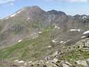
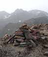
In the morning I had work to do. I had a peak to climb, and I wanted to get as much of the ascent as possible out the way before the sun rose. Fortunately the path zig-zagged profusely up the west side of the mountain, so I was able to do pretty much the whole 600m distance up to the ridge out of the heat.

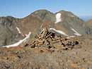
The summit of Pique d'Endron
A walk along the ridge which seemed longer than I had forecast took me to the summit of the Pique d'Endron, 2472m, by 10:45. The photograph here looks towards the Montcalm / Estats group, in the distance behind the cairn, and the Étang d'Izourt reservoir and its surrounding peaks to the left.
The Pique d'Endron was my last summit of the trip - but I still had some way to go down. I went down the most popularly used path up the mountain, on the north-east ridge, and later followed the GR10 down through the villages of Lercoul and Siguer. A long, and frankly horrible road walk, past some unacceptably expensive campsites eventually brought me in to the town of Tarascon-sur-Ariège. I stayed at a campsite there for 3 nights while I ate large amounts of food to make up for the past 12 days!

Grotte de Bédeilhac
The hillsides of the Ariège valley are filled with caves, some of the systems being extremely extensive and reaching far into the hills, and many of them having been inhabited in prehistoric times. The Grotte de Bédeilhac is one such cave, and is notable for its
huge entrance. It's so large that during the second world war, they actually used it as a runway, aeroplanes starting inside and taking off as they left the cave-mouth.
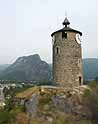
The old tower on the hill in the centre of Tarascon
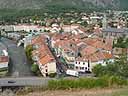
Looking down west on to Tarascon from beside the tower

Looking north across Tarascon

The fun-fair on one of the squares in Tarascon, at night

This was just such a cute kitten!
Copyright © 2004-2005 David R Edgar